Why Could Hurricane Nolo Flood Hawaii Even If Its Center Stays Offshore?
If Hurricane Nolo’s center is expected to remain south of Hawaii, shouldn’t the Big Island be mostly out of danger?
That is the easy assumption to make when looking at a hurricane track. But a hurricane is not a dot moving across a map. Its rain bands, wind field, waves, and moisture can spread far beyond the eye—and those outer effects can become especially dangerous when they reach mountainous islands.
By 2 p.m. HST on September 25, Nolo had maximum sustained winds of 105 mph and was about 155 miles south of South Point, moving north-northeast at only 5 mph. The forecast still kept the center south of the main Hawaiian Islands before a westward turn, yet forecasters were warning about potentially life-threatening flooding on the Big Island. (National Hurricane Center)
That apparent contradiction is the key to understanding this storm.

The important question is not simply, “Will the eye cross the coastline?”
It is: “Where will the storm’s moisture, rain bands, wind, and waves go—even if the eye never gets there?”
What Changed With Hurricane Nolo on Friday?
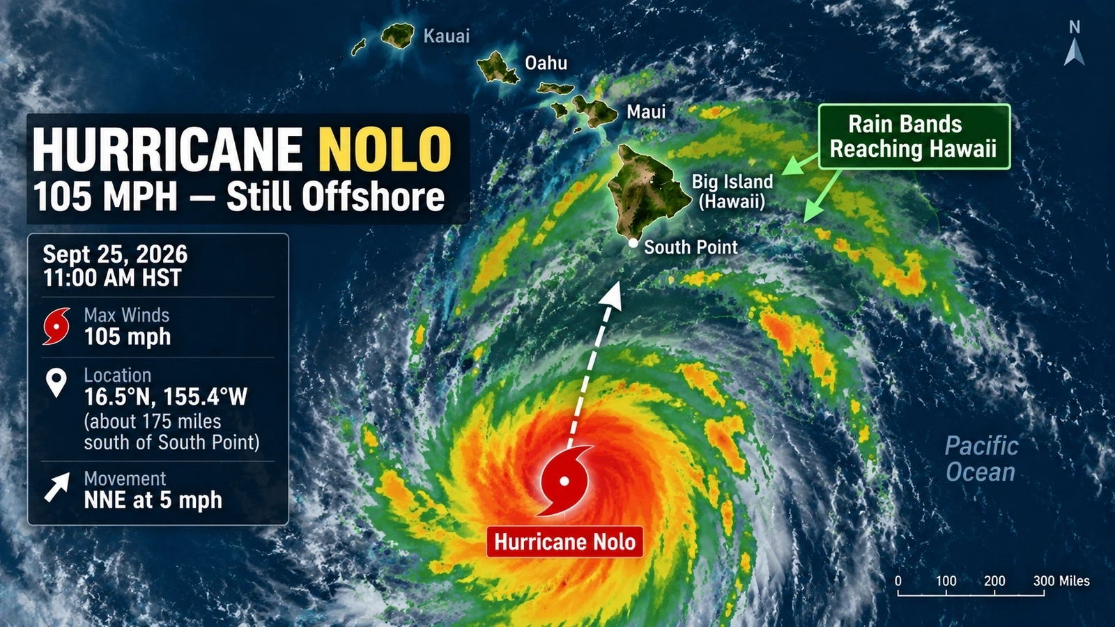
Nolo strengthened sharply on September 25. At 11 a.m. HST, the National Hurricane Center put its sustained winds at 105 mph, making it a Category 2 hurricane, with the eye about 175 miles south of South Point and a minimum central pressure of 978 millibars. (National Hurricane Center)
By the 2 p.m. HST intermediate update, reconnaissance data still supported 105 mph winds, while the minimum pressure had fallen to 975 millibars and the eye had moved to about 155 miles south of South Point. (National Hurricane Center)
The forecast called for Nolo to slow before turning west over the weekend, with its center remaining south of the main Hawaiian Islands. But the storm’s circulation was already large enough that tropical-storm-force winds extended far from the center. (National Hurricane Center)
The rain forecast had also been lowered by Friday morning. A late-Thursday advisory called for 15 to 30 inches across eastern and southern parts of the Big Island, with isolated totals up to 35 inches. By the 5 a.m. HST Friday advisory, the forecast had been reduced to 10 to 15 inches, with isolated totals up to 25 inches. (National Hurricane Center — late Thursday · National Hurricane Center — Friday morning)
That reduction was meaningful, but 10 to 25 inches of rain was still enough for forecasters to warn of catastrophic, life-threatening flooding and mudslides in the hardest-hit areas. (National Hurricane Center)
How Can a Hurricane Flood Hawaii Without Making Landfall?
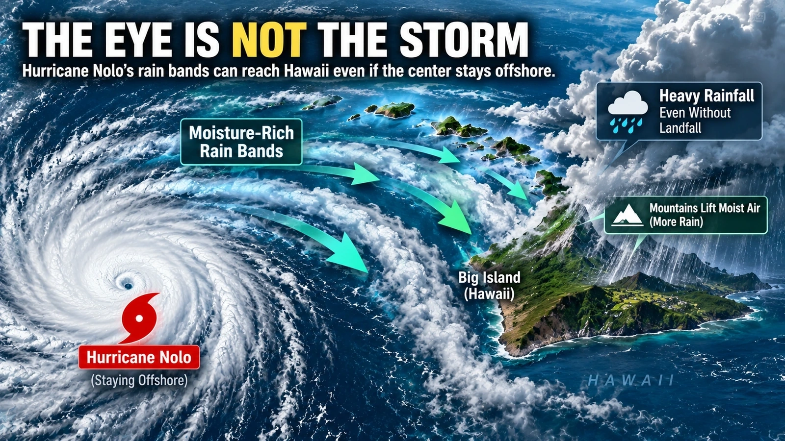
Because landfall describes what the storm’s center does—not where all of its dangerous weather occurs.
A tropical cyclone is an enormous rotating system. The eye may remain over open water while bands of deep tropical moisture wrap hundreds of miles around the center and move across land.
The National Hurricane Center explicitly warns that a tropical cyclone should not be treated as a single point. Wind and other impacts can extend well outside the forecast path of the center. (National Hurricane Center)
With Nolo, the National Weather Service in Honolulu identified a particularly important setup: moisture on the north side of the hurricane was expected to interact with the terrain of the Big Island and Maui. Forecasters said that combination could produce significant flash flooding, especially on the windward and southeastern side of the Big Island. (National Weather Service Honolulu)
Think of the hurricane’s eye as the hub of a huge spinning wheel.
The hub does not have to roll over your house for one of the wheel’s outer sections to pass over you.
Why Does Hawaii’s Terrain Make the Rain More Dangerous?
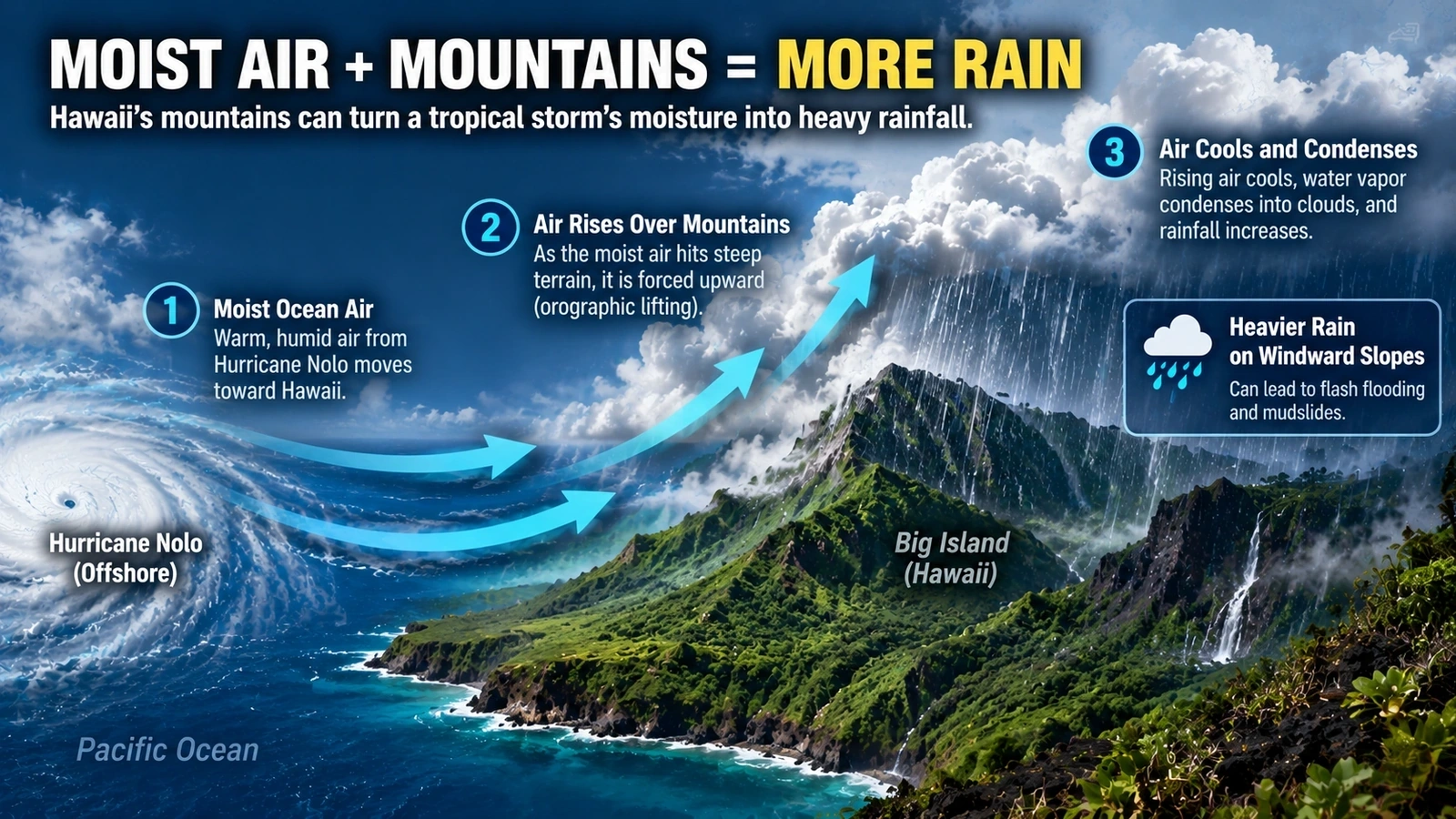
Hawaii’s mountains can turn a wet tropical air mass into an even more serious rainfall problem.
When moisture-laden air reaches steep terrain, it can be forced upward. As the air rises, it cools; water vapor condenses into clouds, and precipitation can increase. Meteorologists call this orographic lifting.
The National Weather Service notes that Hawaii’s mountains are a major reason rainfall varies so dramatically across the islands. Warm, moist air rising over windward slopes often produces much more rainfall than over the nearby open ocean or sheltered leeward areas. (National Weather Service)
That helps explain why Nolo’s forecast was so uneven.
| Area | NHC rainfall forecast on September 25 |
|---|---|
| Eastern and southern Big Island | 10–15 inches, isolated totals up to 25 inches |
| Western Big Island | 2–4 inches, isolated totals up to 8 inches |
| Maui | 4–6 inches, isolated totals up to 10 inches |
| Rest of the Hawaiian Islands | 1–3 inches, isolated totals up to 5 inches |
Those differences are not simply about distance from the eye. Wind direction, rain-band placement, elevation, and mountain orientation can determine where tropical moisture is concentrated. (National Hurricane Center)
And once very heavy rain falls on steep slopes, the problem is no longer just rainfall. Fast runoff, rapidly rising streams, flash flooding, and mudslides become part of the hazard.
What Does the Hurricane Forecast Cone Actually Tell You?
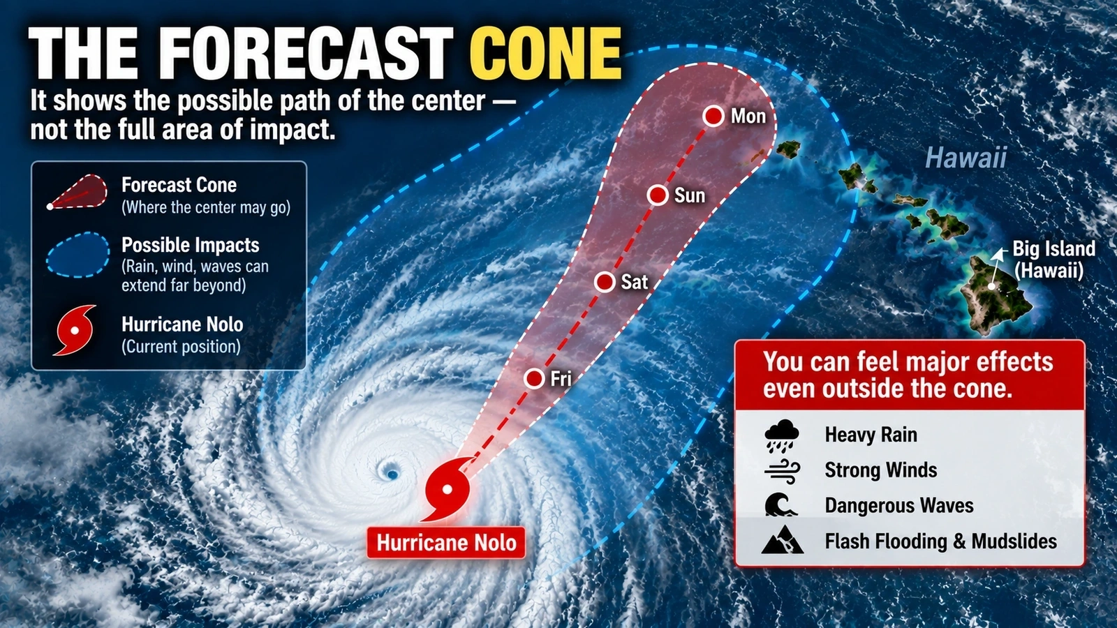
This is one of the most common hurricane-map misunderstandings.
The familiar cone is primarily a way of showing uncertainty in the future track of the storm’s center. It is not a line separating “danger” from “safe.”
The National Hurricane Center specifically cautions that tropical cyclones are not points and that their effects can extend far beyond the cone. The center can follow a path entirely over water while rain bands, tropical-storm-force winds, waves, and other hazards reach land. (National Hurricane Center)
So if Nolo’s center remains south of Hawaii, that tells us something important about the most likely track.
It does not tell us that the Big Island will remain outside the storm’s influence.
That distinction is why emergency officials focus on local rainfall, wind, flood, surf, and warning products—not just where the black centerline appears on a map.
Does “Category 2” Tell Us How Bad the Flooding Could Be?
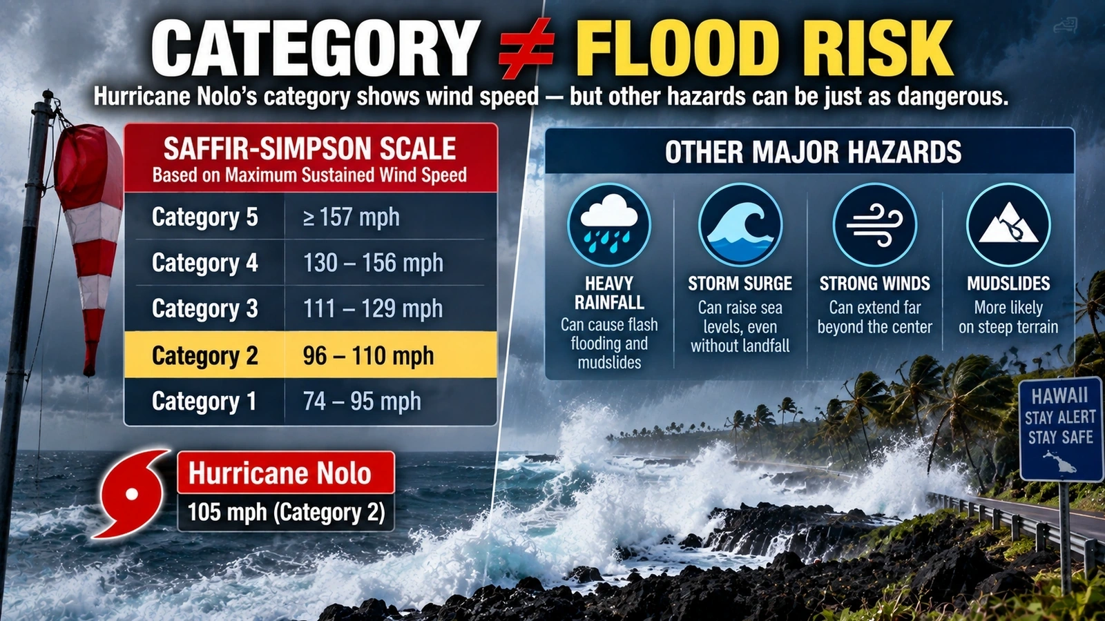
No.
At 105 mph, Nolo was a Category 2 hurricane because Category 2 covers sustained winds of 96 to 110 mph. But the Saffir-Simpson Hurricane Wind Scale is exactly what its name says: a wind scale.
It does not rate rainfall flooding, storm surge, or tornado risk. (National Hurricane Center)
That means a person looking only at “Category 2” could miss the hazard forecasters were emphasizing most strongly for the Big Island: water.
The September 25 NHC advisory warned not only about heavy rainfall but also about a possible 1-to-3-foot storm surge in Hawaii County, along with large waves and dangerous surf. (National Hurricane Center)
This is why a hurricane’s category should never be used as a complete measure of how dangerous the storm is to a particular place.
Why Are Officials Taking Precautions Before the Eye Gets Close?
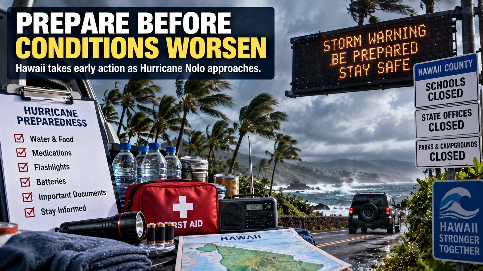
Because hurricane preparations become much harder once strong winds and flooding begin.
Hawaii officials ordered state and county offices, public schools, and University of Hawaii facilities on Hawaii Island to close on Thursday and Friday. Closures expanded into Maui County on Friday, while state parks, forest lands, and camping areas were also closed in several affected islands. (Hawaii Governor’s Office)
As of the 11 a.m. NHC advisory Friday, Hawaii County remained under both a Hurricane Watch and a Tropical Storm Warning, while Maui County was under a Tropical Storm Watch. (National Hurricane Center)
Those terms have different meanings.
| Alert | What it means |
|---|---|
| Hurricane Watch | Hurricane conditions are possible in the specified area |
| Tropical Storm Warning | Tropical storm conditions are expected |
| Tropical Storm Watch | Tropical storm conditions are possible |
These definitions match the National Hurricane Center’s warning language for Nolo. (National Hurricane Center)
A watch does not mean disaster is certain.
It means people should be ready before conditions make final preparations difficult or unsafe.
What Should Hawaii Watch Next?
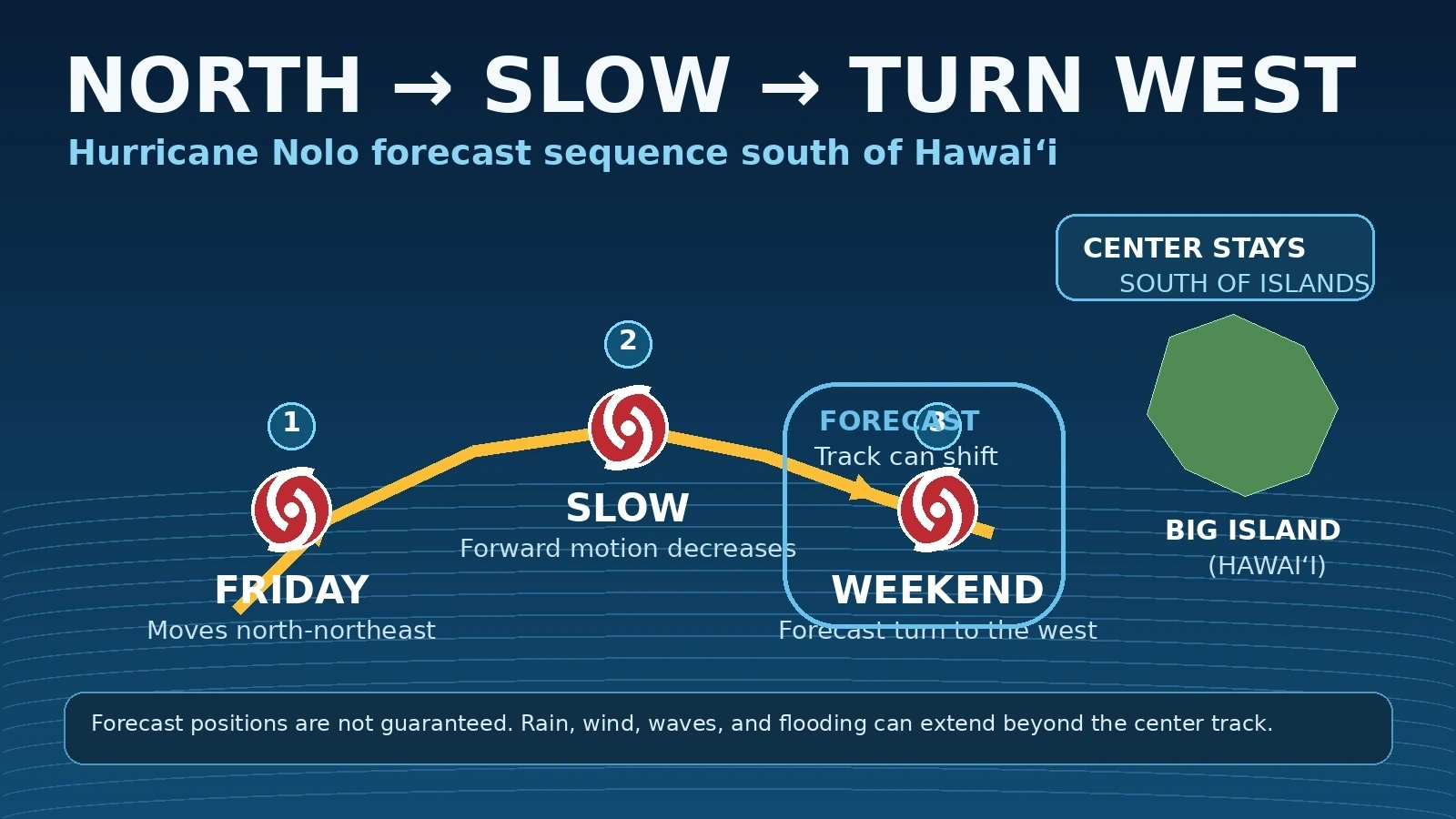
The next major question is whether Nolo makes the expected westward turn on schedule—and how close it gets to the Big Island before doing so.
At 2 p.m. HST Friday, the hurricane was still moving north-northeast at about 5 mph, roughly 155 miles south of South Point. The National Hurricane Center continued to forecast strengthening into a major hurricane over the weekend. (National Hurricane Center)
The track matters, but rainfall placement may matter just as much.
A relatively small shift in the storm’s circulation or rain bands could change which slopes receive the heaviest rain. Forecasters will also be watching how quickly the storm turns west, how much additional strengthening occurs, and whether the strongest rain repeatedly moves over the same areas.
That is why the safest way to follow Nolo is not to watch only one map.
Watch the storm track, but also watch local flood warnings, rainfall forecasts, wind warnings, and emergency instructions.
Why It Matters in One Sentence
Hurricane Nolo shows why an offshore hurricane can still be extremely dangerous: the eye may stay over water while the storm’s moisture, rain bands, winds, waves, and terrain-enhanced rainfall reach land.
Hurricane Nolo: Key Questions Explained
Q. Is Hurricane Nolo expected to make landfall on the Big Island?
The National Hurricane Center’s September 25 forecast kept Nolo’s center south of the main Hawaiian Islands before a westward turn. Forecast tracks can change, so an offshore forecast does not eliminate the need to monitor later advisories. (National Hurricane Center)
Q. How strong was Hurricane Nolo on September 25?
At 2 p.m. HST, Nolo had maximum sustained winds near 105 mph, making it a Category 2 hurricane. (National Hurricane Center)
Q. How can Hawaii flood if the hurricane stays offshore?
A hurricane’s rain bands and moisture extend well beyond its eye. Nolo’s northern moisture field was forecast to interact with the Big Island’s terrain, increasing the potential for heavy rainfall and flash flooding. (National Weather Service Honolulu)
Q. How much rain could the Big Island receive?
The September 25 forecast called for 10 to 15 inches across eastern and southern parts of the Big Island, with isolated totals up to 25 inches. Western areas were forecast to receive substantially less. (National Hurricane Center)
Q. Does being outside the hurricane cone mean an area is safe?
No. The cone represents uncertainty in the track of the storm’s center. Hurricane impacts can extend far beyond it. (National Hurricane Center)
Q. Does Category 2 measure Hurricane Nolo’s flood risk?
No. The Saffir-Simpson scale is based only on maximum sustained wind speed. Rainfall flooding and storm surge are separate hazards. (National Hurricane Center)
Q. Why are eastern and southern parts of the Big Island at greater risk?
The storm’s moisture is approaching terrain that can force moist air upward and increase rainfall. Hawaii’s steep topography creates large rainfall differences over relatively short distances. (National Weather Service)
Q. What is the most important thing to watch next?
The timing of Nolo’s westward turn, any change in its distance from the Big Island, and local rainfall and flood warnings will be critical. The center track alone does not describe the full hazard.
Did this help make the story clearer? 🙂
WIN keeps unpacking the “why” behind the news—clearly and simply!
Sources
Hurricane Nolo Track, Intensity, and Hazard Forecasts
National Hurricane Center — Hurricane Nolo Public Advisory No. 21
National Hurricane Center — Hurricane Nolo Public Advisory No. 20
National Hurricane Center — Hurricane Nolo Forecast Discussion No. 21
National Hurricane Center — Hurricane Nolo Intermediate Public Advisory No. 21A
Rainfall, Terrain, and Hurricane Risk
National Weather Service Honolulu — September 25 Area Forecast Discussion
National Weather Service — Climate of Hawaii
National Hurricane Center — How to Use the Hurricane Forecast Cone
National Hurricane Center — Saffir-Simpson Hurricane Wind Scale
Hawaii Closures and Preparedness
Office of the Governor of Hawaii — Nolo-Related Government and School Closures
Hawaii Department of Land and Natural Resources — Park and Forest Closures